Products and Tools for Energy Modelling
 > Click here to access the web-based Energy Forecast Mapping Tool
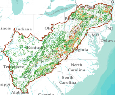
The web-based mapping tool of this energy assessment combines multiple layers of data on energy development trends and important natural resource and ecosystem services, to give a more comprehensive picture of what potential energy development could look like in the Appalachians. The tool shows where energy development is most likely to occur and indicates areas where such development may intersect with other significant values like intact forests, important streams, and vital ecological services such as drinking water supplies.
In this study funded by the Appalachian LCC, The Nature Conservancy assessed current and future energy development across the entire region. Major results indicate that nearly 7.6 million acres of new energy-related development could occur in the region by 2035, concentrated in the Allegheny and Cumberland Plateaus. Over 5 million acres of energy-related development will likely occur in forested areas. There is high potential for development to occur in more than 150 watersheds, which are important drinking water sources in those same areas.
The goal of this report was to create a spatial model for the Appalachian LCC predicting where surface coal mining is likely to occur in a projected future time period, under two different scenarios. To accomplish this goal, researchers combined GIS spatial analysis, a Random Forests predictive model, and future mining buildout scenarios. This report provides a detailed methodology of the approach and discussion of the results.
View a video presentation that provides a detailed overview of how to use the Energy Forecast Mapping Tool
This video presentation by Judy Dunscomb, Senior Conservation Scientist at The Nature Conservancy, provides a detailed overview of how to use the Energy Forecast Mapping Tool and the data layers currently available.


